
By yesterday, Dave, a Law Enforcement Trainee, and me, the only current residents of the bunkhouse were both climbing the walls.
Our exciting, interesting experience had gone way south and we both felt like prisoners. Dave much more than me, because I, at least, have my own vehicle while he is driving a government vehicle and can't use it for personal trips. But both of us are confined mostly to the bunkhouse while on the refuge. Dave also has been away from his family because of this training and was looking forward to spending one night with them, while traveling to Missisippi. But he has been locked in to here, while the refuges are shut down.
I decided enough was ENOUGH, and invited Dave, who was on days off, to go with me on an outing. (Law Enforcement people are still on duty to protect the refuges.) The ground rules were that we were going to head west to Thompson Falls where there is a place where big-horn sheep are easy to spot. Other than that, we would stop as often as either of us wanted, and go wherever we decided to. And it was already a given, that we would discuss our situation or make guesses as to when we could be normal again. So we packed food, water, extra clothes, binoculars and camera and got around to leaving about ten, after waiting to see if the weather was going to cooperate.
We only had to take Highway 212, to 200 and head west. Highway 200 is described, correctly, as a scenic highway. We went through the tiny town of Dixon and soon were traveling through a beautiful valley built by the Flathead River, with views of a few high mountains dressed in new snow veils. The air was cool, crisp and blown about by a north wind. Just getting out of the car to take pictures or scan for wildlife started the rise of our moods.
At one stop, Dave found at least 100 big-horned sheep and lambs. They were so far away, that, when I zoomed in took the picture, then enlarged the picture in my camera, I could still barely tell what they were.
Just before we got to Paradise, the Flathead River ran into the Clark Fork River, but the road mostly continued to follow the Clark Fork River, on one side or the other. So, the scenery remained gorgeous with only the name of the river changing. We stopped at one river access point, Pair-of-Dice which is at the edge of the town of Paradise. For a moment I was transported to the Hill Country Area of Texas by the sight of a long-horned cow. It even had the don't-fence-me-in attitude that we had - it had gotten out of its pasture.
We continued through Plains where I decided to go visit the Lolo Forest Ranger Station until Dave reminded me they also closed by the government, so we would not be able to get any information on hiking. But a few miles further, we saw a forest road that looked intriguing and we both agreed we'd like to travel it. We wound upward through a mostly evergreen forest of pines and spruces. We came to an intersection with a sign leading to a fire tower and both wanted to visit it. But my little Honda Fit didn't seem up to the narrow, muddy, tracked road so we bypassed it and continued upward.
Right on the top, we crossed a trail and decided to park and walk it. We took it until we found another road, then walked that road, plus a logging trail back to our trail, and shortly after, to the car. Both of us really enjoyed the activity and the new views. We only hiked about three miles but what a vast improvement it was over our bunkhouse lives.
I had expected that the road would take us near to Thompson Falls but I think I took the wrong turn. We finally ended up back in Plains after winding down and around the mountain, and had to travel a few miles of Highway 200 that we seen earlier. We only had to stop once, to watch turkey's crossing the road.
It was mid-afternoon before we reached the pull-out that is the place to sit and watch for big-horned sheep. We didn't see any, either time we stopped, but did see a pair of ewes grazing between us and the railroad, which runs along the river. The railroad was fenced off here to protect the sheep. The road had lots of warning signs to watch for the sheep in the road.
While driving around in Thompson Falls, we saw a sign for the Jailhouse Museum. We both decided to go there, but then our eyes reached a sign hung on the bottom which said, "Closed for Season". We stopped in at a gas station for coffee and asked the lady there if there were any interesting walks in town. She suggested we go walk the island and see the dams that provide power to the area.
So we drove another block, made a left turn, and found the parking lot. Then we explored the trails that led to the high dam and the fish ladder, a bridge built to haul materials to build the dams, but which is just for pedestrians now, and the trail to the low dam and powerhouse. There was lots of signage explaining how the dams worked and how the fish ladders were later installed at the cost of several million dollars to provide access to fish swimming upstream to spawn.
We left Thompson Falls and decided to come home by a much more roundabout way that would have involved us going north and east to Poulson, and then coming back to the refuge. But about the time we got to Hot Springs, Dave remembered he needed to be at the bunkhouse in time for his wife to call him. So we turned around and started home by the shortest route. This took us by Rainbow Lake and we decided we could spend a few minutes there. Before we had gotten out of the car, we spotted an eagle who seemed to be trying to sit on a limb, and look for a fish, but was being blown about. Then we enjoyed a short walk along the lake before driving home.
We came back in great moods, and were so relaxed, we both slept longer than usual.
Now, the following morning, I'm about to go vacuum my car, then pack in everything I can live without for the next few days. I am expecting to be able to make the decision to leave by Monday night or early Tuesday morning. As soon as my bosses decide that we won't have the time or manpower to have the Big Sit, even if we reopen by October 9, I'm going to leave.
One of my mottoes is" If it ain't fun, don't do it." Here, I'm neither having fun nor feeling of any use. So now I'm dreaming of visits to friends and family and lots of paddles.
Our exciting, interesting experience had gone way south and we both felt like prisoners. Dave much more than me, because I, at least, have my own vehicle while he is driving a government vehicle and can't use it for personal trips. But both of us are confined mostly to the bunkhouse while on the refuge. Dave also has been away from his family because of this training and was looking forward to spending one night with them, while traveling to Missisippi. But he has been locked in to here, while the refuges are shut down.
I decided enough was ENOUGH, and invited Dave, who was on days off, to go with me on an outing. (Law Enforcement people are still on duty to protect the refuges.) The ground rules were that we were going to head west to Thompson Falls where there is a place where big-horn sheep are easy to spot. Other than that, we would stop as often as either of us wanted, and go wherever we decided to. And it was already a given, that we would discuss our situation or make guesses as to when we could be normal again. So we packed food, water, extra clothes, binoculars and camera and got around to leaving about ten, after waiting to see if the weather was going to cooperate.
We only had to take Highway 212, to 200 and head west. Highway 200 is described, correctly, as a scenic highway. We went through the tiny town of Dixon and soon were traveling through a beautiful valley built by the Flathead River, with views of a few high mountains dressed in new snow veils. The air was cool, crisp and blown about by a north wind. Just getting out of the car to take pictures or scan for wildlife started the rise of our moods.
 |
| Highway 200 view looking south early in our trip |
 |
| And the view looking north from the same scenic pullout |
 |
| I had to climb down the bank a little ways to catch this bank of blooming rabbitbush |
At one stop, Dave found at least 100 big-horned sheep and lambs. They were so far away, that, when I zoomed in took the picture, then enlarged the picture in my camera, I could still barely tell what they were.
 |
| Some of a huge herd of big-horn ewes and lambs |
 |
| Another view of the Flathead River from a fishing access point |
Just before we got to Paradise, the Flathead River ran into the Clark Fork River, but the road mostly continued to follow the Clark Fork River, on one side or the other. So, the scenery remained gorgeous with only the name of the river changing. We stopped at one river access point, Pair-of-Dice which is at the edge of the town of Paradise. For a moment I was transported to the Hill Country Area of Texas by the sight of a long-horned cow. It even had the don't-fence-me-in attitude that we had - it had gotten out of its pasture.
 |
| Longhorn |
 |
| View of river after it crossed the road |
We continued through Plains where I decided to go visit the Lolo Forest Ranger Station until Dave reminded me they also closed by the government, so we would not be able to get any information on hiking. But a few miles further, we saw a forest road that looked intriguing and we both agreed we'd like to travel it. We wound upward through a mostly evergreen forest of pines and spruces. We came to an intersection with a sign leading to a fire tower and both wanted to visit it. But my little Honda Fit didn't seem up to the narrow, muddy, tracked road so we bypassed it and continued upward.
Right on the top, we crossed a trail and decided to park and walk it. We took it until we found another road, then walked that road, plus a logging trail back to our trail, and shortly after, to the car. Both of us really enjoyed the activity and the new views. We only hiked about three miles but what a vast improvement it was over our bunkhouse lives.
 |
| View on our hike - think the snow-covered mountain is Old Baldy |
I had expected that the road would take us near to Thompson Falls but I think I took the wrong turn. We finally ended up back in Plains after winding down and around the mountain, and had to travel a few miles of Highway 200 that we seen earlier. We only had to stop once, to watch turkey's crossing the road.
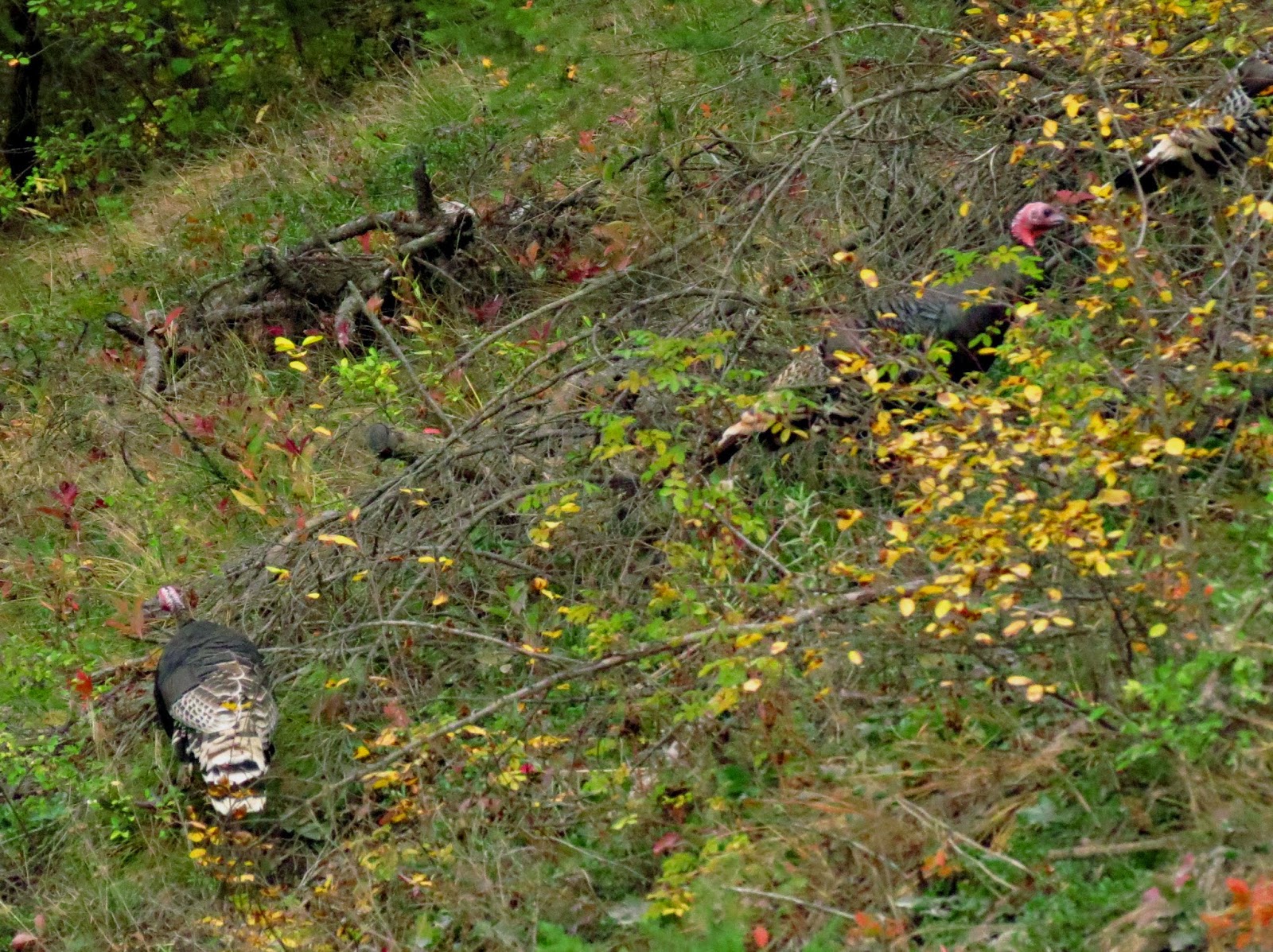 |
| A few of the flock of about twenty turkeys we found in Lolo Forest |
It was mid-afternoon before we reached the pull-out that is the place to sit and watch for big-horned sheep. We didn't see any, either time we stopped, but did see a pair of ewes grazing between us and the railroad, which runs along the river. The railroad was fenced off here to protect the sheep. The road had lots of warning signs to watch for the sheep in the road.
While driving around in Thompson Falls, we saw a sign for the Jailhouse Museum. We both decided to go there, but then our eyes reached a sign hung on the bottom which said, "Closed for Season". We stopped in at a gas station for coffee and asked the lady there if there were any interesting walks in town. She suggested we go walk the island and see the dams that provide power to the area.
So we drove another block, made a left turn, and found the parking lot. Then we explored the trails that led to the high dam and the fish ladder, a bridge built to haul materials to build the dams, but which is just for pedestrians now, and the trail to the low dam and powerhouse. There was lots of signage explaining how the dams worked and how the fish ladders were later installed at the cost of several million dollars to provide access to fish swimming upstream to spawn.
 |
| The High Dam |
 |
| Fish Ladder - Fish zig-zag up through it to the high lake. |
 |
| Interesting rock outcropping on the dam island |
 |
| View of the low dam and the powerhouse |
We left Thompson Falls and decided to come home by a much more roundabout way that would have involved us going north and east to Poulson, and then coming back to the refuge. But about the time we got to Hot Springs, Dave remembered he needed to be at the bunkhouse in time for his wife to call him. So we turned around and started home by the shortest route. This took us by Rainbow Lake and we decided we could spend a few minutes there. Before we had gotten out of the car, we spotted an eagle who seemed to be trying to sit on a limb, and look for a fish, but was being blown about. Then we enjoyed a short walk along the lake before driving home.
 |
| Eagle at Rainbow Lake |
We came back in great moods, and were so relaxed, we both slept longer than usual.
Now, the following morning, I'm about to go vacuum my car, then pack in everything I can live without for the next few days. I am expecting to be able to make the decision to leave by Monday night or early Tuesday morning. As soon as my bosses decide that we won't have the time or manpower to have the Big Sit, even if we reopen by October 9, I'm going to leave.
One of my mottoes is" If it ain't fun, don't do it." Here, I'm neither having fun nor feeling of any use. So now I'm dreaming of visits to friends and family and lots of paddles.


